Kumbali Projekt e.V. |
 |
 |
Contents. 
Photo: Maergner 
. 
. 
Photo: Maergner 
. 
. 
|
About usKumbali Projekt e.V.Grit Wagner-Strohn Brunnweinbergstr. 2 D-71334 Waiblingen Tel.:+49(0)7151 277003 Fax: +49(0)7151 277004 Mobile:+49(0)17627180767 mailto:kumbali@railcat.de URL: http://www.kumbaliprojekt.de |
 Deutsche Version
The Country |
The Warm Heart of AfricaThe Warm Heart of Africa is Malawi called quite rightly, and its inhabitants stand by the slogan with heart and soul. In this friendly and peaceful country, one meets with affection, mindfulness and interest everywhere. Despite all problems - even facing a difficult economical and political situation at present - the people exude a profound agreement with life.
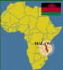
GeographyMalawi is situated in the southern part of the East African Rift. With an area of 118,484 km², a north-south length of 850 km and a west-east width of 350 km it is a comparatively small country. The landscape is characterised through plateaus that are dominated by inselbergs, wide lowlands and the Lake Malawi. The latter, well known to aquarium enthusiasts, is the third largest inland lake of Africa. In the east, south and southwest, Mozambique encloses the country like a large pair of pliers. Other neighbour countries are Zambia in the west and Tanzania to the north. The climate is subtropical with three main seasons - cool, hot, rainy -; main rainfalls occur from December through March.PopulationMalawi has a population of about 20 million inhabitants with a growth rate of 2.5%; 51% are less than 18 years old. Approximately 10% of the adults live with the HIV/AIDS disease, 9.1% of the children and adolescents are orphans or half-orphans. Population density is 200 per km²; only 17% live in urbanised areas. 90% of the children of school age visit a school, but there is still a lack of schools and teachers as well. The literacy rate - i.e. the proportion of those who can at least read and write simple sentences - for the population aged 5 and over is 65.4% and 75.5%, respectively, aged 15 and over. Besides the official languages English and Chichewa several Bantu languages are spoken. 77% of the population is Christian.Politics and EconomyMalawi is a parliamentary presidential republic and member of the Commonwealth of Nations. President and parliament are elected every 5 years. 73% of the inhabitants live on agriculture. Main crops are maize for home requirements, and tobacco, tea and sugar cane for export. The Gross National Income (Atlas method) per capita declined from 490 US$ in 2011 to 340 US$ in 2016 and then increased to 580 US$ (2020). Inflation rate was in a two-digit range (24.1% in 2014) for quite some years but has stabilized at around 9% since 2018. More than 88% of the population have a drinking water supply, but only 35% have access to sanitary facilities. 50.7% live below the official poverty line, 20.8% even in extreme poverty. Currency is the Malawi Kwacha; 1 EUR corresponds to approx. 2050 MWK (11th April 2024). |
